Winter Recreation Planning
California’s central and northern Sierra Nevada are ground-zero for winter travel planning. With six “early adopter” forests — the Lassen, Tahoe, Eldorado, Stanislaus, and Plumas National Forests, and the Lake Tahoe Basin Management Unit — this region is the first to go all-in on the OSV Rule.
- Stanislaus National Forest (completed):
- After six years of meetings, field trips, 670 individual comments from individuals and organizations, dozens of maps, reams of documents, and more meetings — the Stanislaus National Forest completed its Over-Snow Vehicle Use Designation Project. The final signed Record of Decision was released July 13, 2021.
- Click here for our take on the final plan: not great, but better than what had been status quo, with some important preliminary protections established for wildlife and quiet recreation.
- On October 13, 2021, the Sierra Snowmobile Foundation, Blue Ribbon Coalition, the American Council of Snowmobile Assoc. and others filed a lawsuit against the United States Forest Service. Click here to see the complaint.
- Now, we are working with the Stanislaus on OSV plan implementation (see below)
- Lassen National Forest:
- The Lassen published a Final Environmental Impact Statement (FEIS) and Record of Decision (ROD) in June, 2022.
- The plan protects quiet recreation opportunities in many of the important non-motorized recreation areas WWA and our partners advocated for, including the McGowan National Recreational Trail, Elam Creek/Carter Meadow, the West Shore of Lake Almanor, Hog Flat reservoir, and the West Shore of Eagle Lake. Click here for our full review.
- Now, we are working with the Lassen on implementation.
- Tahoe National Forest (completed):
- The Tahoe published a Final Environmental Impact Statement (FEIS) and Record of Decision (ROD) on May 3, 2024.
- The final plan allows for OSV use in most areas and all trails, where people have typically taken snowmobiles in the past, it also secures non-motorized protections for key zones and promotes quiet recreation experiences along the Pacific Crest Trail.
- Click here for the final plan.
- Plumas National Forest:
- A draft Record of Decision (ROD) and Final Environmental Impact Statement (FEIS) were published on August 19, 2019.
- After 17 hours of virtual “objection workshops” in May 2021, an official objection resolution meeting was held on June 3, 2021.
- On July 12, 2021, the regional Reviewing Officer issued a letter of review.
- We hope to see a signed Record of Decision (ROD) by the end of 2025.
- Eldorado National Forest:
- The Eldorado released its Draft Record of Decision and Final Environmental Impact Statement (FEIS) on October 31, 2018. The Forest Service held an objection meeting in March 2019.
- We hope to see a signed Record of Decision (ROD) by the end of 2025.
- Lake Tahoe Basin Management Unit (LTBMU)
- The LTBMU published a Proposed Action on September 2019, and public comments were accepted through December 9, 2019. There will be an additional comment period at the end of 2025.
- Inyo National Forest,
- Published a new Forest Plan in October 2019. With regard to winter recreation/travel planning, Forest Supervisor Tammy Randall-Parker wrote in her final Record of Decision that “over-the-snow (winter) travel will be determined by Subpart C Travel Management Analysis, on which I am committing to initiating the public collaboration process within one year of this decision.”
- Scoping for the winter travel plan was in October 2023. Draft EA expected in July 2024.
Forest Planning
- Sierra and Sequoia National Forests: With our Outdoor Alliance California partners (Access Fund, American Whitewater, IMBA, CAMTB) and local grassroots groups, we have worked throughout the forest plan revision process to advocate for conservation goals and for the preservation and enhancement of human-powered recreation opportunities and equitable access on these popular Southern Sierra Nevada forests. Final plans and Records of Decision (RODs) are slated to be published early in 2022.
- Northwest Forest Planning: Four Northern California forests are currently in the assessment phase leading up to a multi-year, once-in-a-generation forest plan revision process. With our Outdoor Alliance California partners (Access Fund, American Whitewater, IMBA, CAMTB) and local grassroots groups, we are currently ramping up our own assessments and GIS inventories of conservation and human-powered recreation issues on these national forests:
- Rogue River – Siskiyou
- Klamath
- Mendocino
- Shasta-Trinity
Informational Materials + Signage
The goal for these initial signage and informational materials is to provide a template that makes it easy for future forests and recreation areas to create their own and get the information that they need to out at trailheads more quickly.
Here are example materials we’ve completed and shared in our California travel planning work:
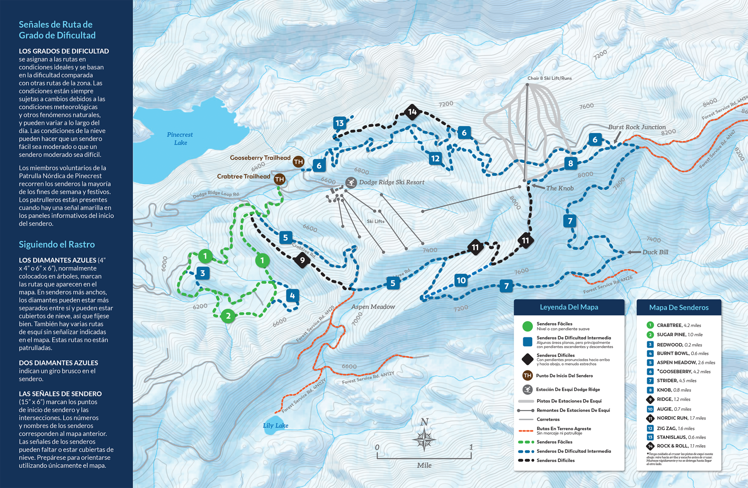
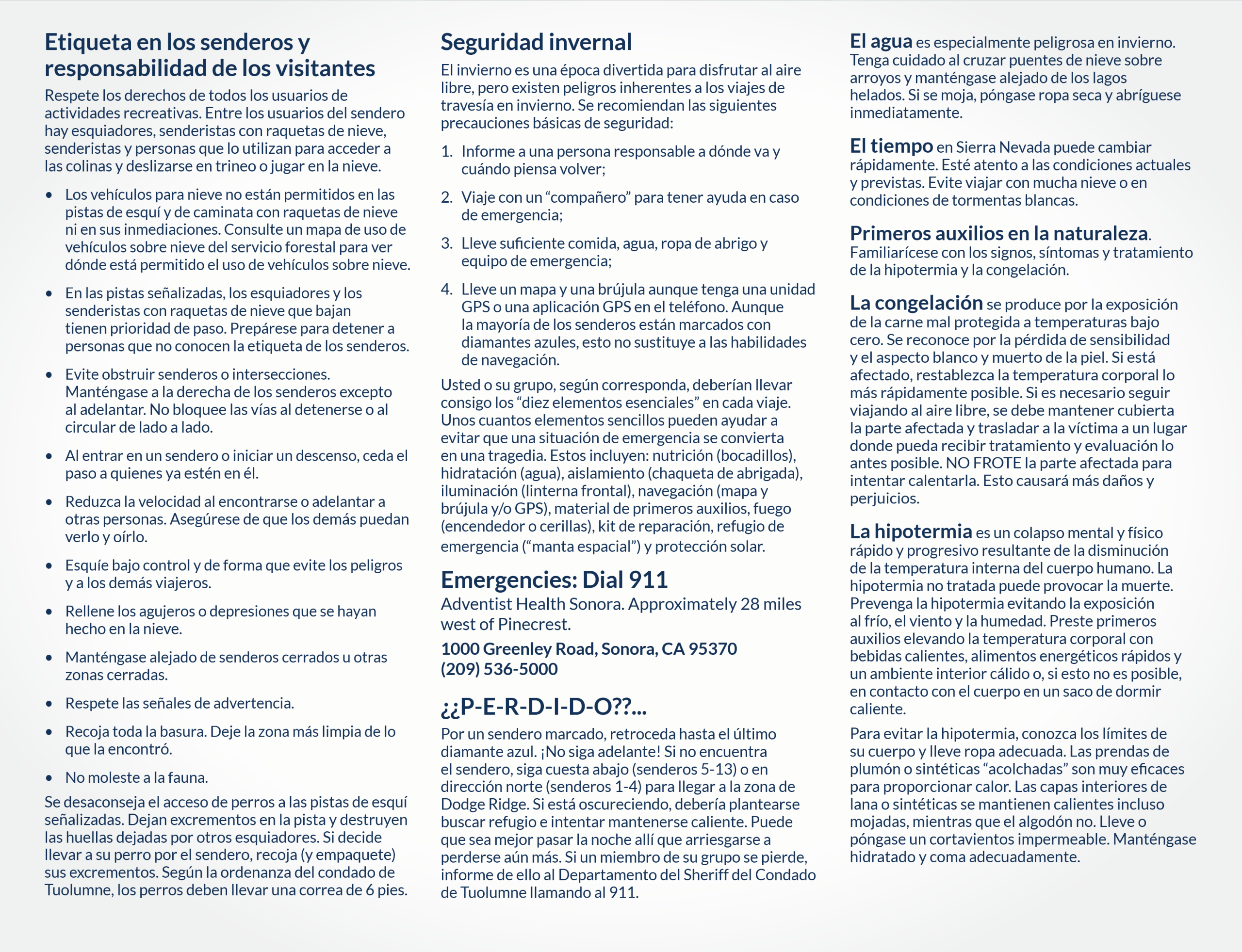
- Stanislaus National Forest – Summit Ranger District Pinecrest Ski Trails Map with a field photo mockup (Spanish Map) and Brochure and Inside & Outside, (Spanish: Inside & Outside)
- Ski Kind
- Recommended Reading from Tread Lightly: Sharing Our Snow
Winter Wildlands Alliance is a national nonprofit organization working to
inspire and empower people to protect America’s wild snowscapes.

![]()


MAIL ADDRESS
910 Main Street
Suite 235
Boise, Idaho 83702
208-336-4203