Record of Decision Signed July 13, 2021
After six years of meetings, field trips, 670 individual comments from individuals and organizations, dozens of maps, reams of documents, and more meetings, the Stanislaus National Forest completed its Over-Snow Vehicle Use Designation Project on July 13, 2021. The Stanislaus now has a winter travel plan. Publication of the Record of Decision on the Stanislaus website is a somewhat anticlimactic end to a long process, but we’re really excited to see the very first winter travel plan completed since the Over-Snow Vehicle (OSV) Rule was published in 2015!
An official Over-Snow Vehicle Use Map (OSVUM) is now available at Stanislaus National Forest offices or online here.
** Note: On October 13, 2021, the Sierra Snowmobile Foundation, Blue Ribbon Coalition, the American Council of Snowmobile Assoc. and others filed a lawsuit against the United States Forest Service. Click here to see the complaint. Meanwhile the plan is still officially in effect, and we are working with forest service staff to ensure its effective implementation.
Importantly, under the new plan, OSV use on the Stanislaus National Forest is only allowed in areas or on trails that have been designated for OSV use. All other areas and trails are closed by default. This is a significant paradigm shift that ensures OSV use only occurs in places where the Forest Service has determined that such use is appropriate and will have a minimal impact on wildlife, forest resources, and other uses. Under the new plan there continue to be thousands of acres available for OSV use on the Stanislaus National Forest, including all of the areas and trails that currently receive high snowmobile use. As the Stanislaus plan demonstrates, winter travel planning does not automatically translate to the closure of popular snowmobiling routes and areas — unless closure is determined to be required in order to minimize impacts to resources or wildlife, or to minimize conflict with other winter recreation uses. In fact the majority of acreage closed under the new plan is below 5,000 feet in elevation, where there is not generally adequate snow for operating OSVs. Here’s a brief rundown of some of the details in the new plan:
What we like:
- Protects important non-motorized winter recreation areas accessed from Highway 108: the Dodge Ridge cross-country ski and snowshoe trail system and the Herring Creek area
- Protects areas for quiet recreation near Bear Valley, CA: Round Valley, much of the Big Meadow campground, the west side of Osborne Hill, and the Lake Alpine area.
- Prohibits OSV use along the majority of the Pacific Crest Trail as it travels through the Stanislaus National Forest
- Limits OSV use in Stanislaus Meadows and Highland Lakes to times when there is at least 24 inches of snow present in order to protect the endangered Sierra Nevada yellow-legged frog and the threatened Yosemite toad
- Closes the Sonora Pass OSV play area on April 15 annually to reduce the risk of OSV use disturbing Sierra Nevada red fox den establishment or facilitating disturbance or predation of fox pups once they leave the den
- Requires a minimum of 12 inches of un-compacted snow before OSV use is allowed in designated areas or on designated trails (and requires at least 18 inches of un-compacted snow on trails prior to initiating grooming each season)
Major disappointments:
- Designates OSV use in 3 high-value quiet recreation areas near Bear Valley: the east side of Osborne Hill, Mattley Ridge, and Cabbage Patch/Black Spring.
- Designates OSV use adjacent to the Pacific Crest Trail at Sonora Pass, in clear violation of the PCT’s comprehensive plan
- Designates a 410-acre OSV play area at Sonora Pass, in critical habitat for the incredibly rare and endangered Sierra Nevada red fox
- Amends the forest plan to reward decades of illegal snowmobiling by designating open areas for OSV use in the Pacific Valley and Eagle/Night Near Natural Areas, which were closed to motorized use in the 1991 Stanislaus Forest Plan
What comes next?
Before the start of this coming winter the Stanislaus will publish an Over-Snow Vehicle Use Map (OSVUM). This map will show which areas and trails are designated for OSV use in the new plan and once the map is published OSV use will only be allowed on those parts of the Stanislaus that are shown as designated on the OSVUM. This makes it much easier for the Forest Service to enforce their new travel regulations. The Forest Service will also need to install new signs in some places to help people understand the new travel regulations, and follow through on monitoring commitments made in the new plan. In addition, the Forest Service will be able to provide better OSV use enforcement, including enforcing illegal OSV use outside the established designated OSV areas and trails. The OSVUM will contain specific information to educate all winter recreation users regarding rules and regulations governing winter recreation on the Forest.
Project Links:
Stanislaus OSV Official Forest Service Project Page
Final ROD (PDF 3059kb)
Final ROD Map (Alternative 5-Modified) (PDF 459kb)
Final Environmental Impact Statement, Volume I (PDF 8696kb)
Final Environmental Impact Statement, Volume II (PDF 4836kb)

Airola Peak, Carson Iceberg Wilderness, Stanislaus National Forest. Photo by Alex Dodov.
Implementation
Now that the travel plan is complete we are working with the Stanislaus National Forest to help develop visitor education materials.
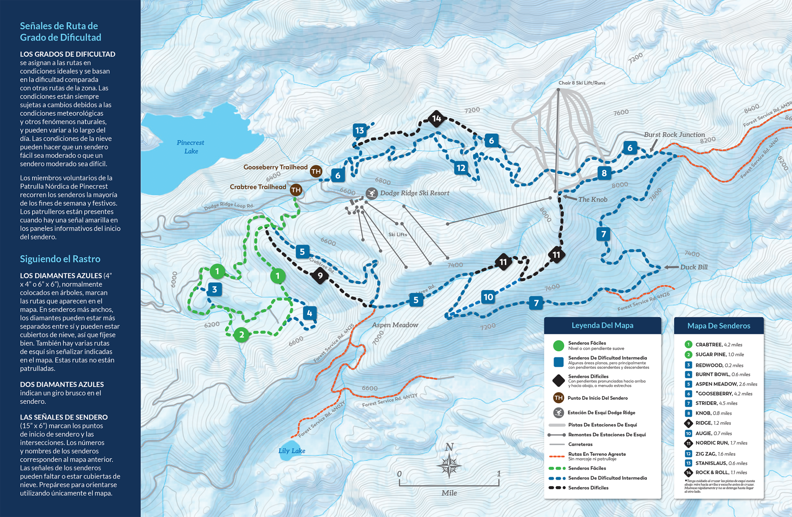
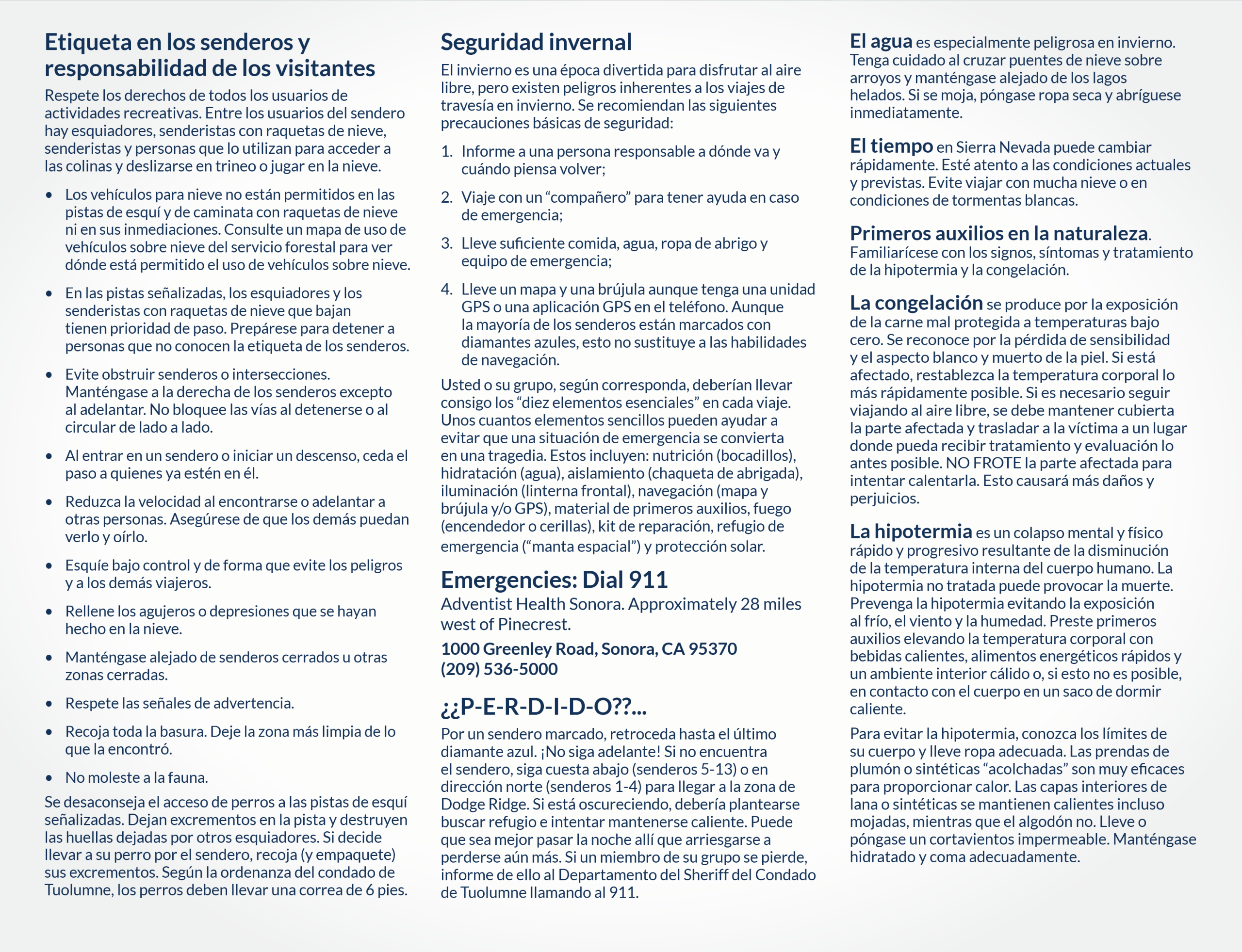
- Summit Ranger District Pinecrest Ski Trails Map with a field photo mockup (Spanish Map) and Brochure and Inside & Outside, (Spanish: Inside & Outside)
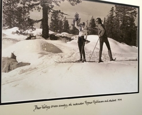
Cross-country skiing on the Stanislaus in 1934


Stanislaus National Forest photos courtesy John Buckley, Central Sierra Environmental Resource Center (CSERC)


![]()