Final Eldorado NF OSV Plan Anticipated in 2024
The Draft Record of Decision and Final Environmental Impact Statement (FEIS) was released in October 2018. Final objection meetings were held in summer 2019. Draft OSV Plan Documents for reference:
- Eldorado National Forest Over Snow Vehicle Use Designation Project Page
- Draft Record of Decision
- Selected Alternative Map
BACKGROUND: Public comments closed August 6, 2018 on the Eldorado National Forest’s Draft Environmental Impact Statement (DEIS) for Over-Snow Vehicle (OSV) management on June 22, 2018. Especially compared with what we saw in the Tahoe Draft OSV Plan, we were disappointed with the level of analysis performed by the forest and with the limited range of alternatives being considered. The forest failed to seriously consider and analyze any significant further restrictions on OSV use and is actually proposing to open many popular and historic cross-country and backcountry ski zones to motorized use.
- NEPA Failure: We believe the Eldorado’s Draft Environmental Impact Statement (DEIS) for over-snow vehicle (OSV) designation fails in a number of ways to comply with NEPA and the 2015 OSV Rule. It does not consider a full range of alternatives (Alts 1, 2 and 4 are essentially the same); it fails to fully address the minimization criteria; it fails to treat the forest as closed to over-snow vehicles unless designated open (as required by law); and it designates open to OSVs areas that are larger than a ranger district. We hope that the Eldorado will go back to the drawing board, as the Lassen did, and significantly revise this draft before moving on.
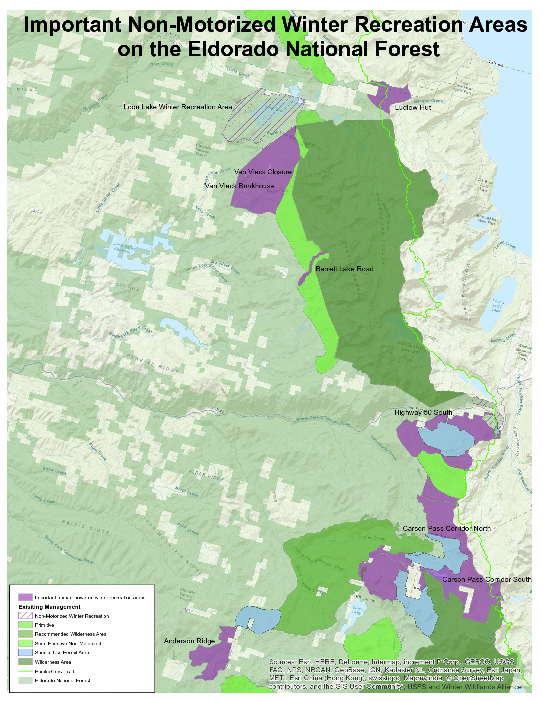
- Important ski and snowshoe zones opened to snowmobiles: Meanwhile, the Eldorado’s Proposed Action (Alternative 2) actually reverses historic protections and opens many important and longstanding non-motorized areas to snowmobiles, including Anderson Ridge, numerous traditionally non-motorized areas accessed from the Carson Pass corridor and the historic Van Vleck closure. It also designates open to OSV use the important non-motorized area around the Ludlow Hut. Alternative 4 is even worse, proposing to allow OSVs in the Loon Lake winter recreation area along with all of the areas listed above. Alternative 4 also proposes to change the Forest Plan to allow OSVs in the Caples Creek recommended wilderness area, semi-primitive non-motorized high country areas, and in the Round Top Biological/Geological Special Interest Area! Click here to use our mapping tool to see how this plan might impact your favorite zones on the Eldorado NF.
Only Alternative 3 presents a clear-eyed vision for winter travel management that recognizes historically non-motorized areas, focuses OSV designations in areas where OSV use actually occurs, and acknowledges that not all parts of the forest receive sufficient snow for OSV recreation. SEE BELOW FOR WINTER WILDLANDS ALLIANCE COMMENT LETTER.
Summary
The FEIS describes five alternatives:
- Alternative 1 (current management): The current management designates 75% of the forest open to snowmobiles and OSV travel. Of the remainder, 17% is designated wilderness. The rest of the winter non-motorized areas on the forest consist of recommended wilderness, primitive or semi-primitive areas, downhill and Nordic resorts, and various special non-motorized areas. This Alternative does not include many historically non-motorized areas because the closure orders protecting them have lapsed. There are 58 miles of groomed snowmobile trail forming the Silver Bear Trail System near Highway 88 west of Silver Lake.
- Alternative 2 (proposed action): The forest’s proposed action is barely distinguishable from current management. This alternative closes an additional 23,000 acres (4%) to OSV use, but the area closed is generally below 4,500 ft in the western portion of the forest and wouldn’t provide any further non-motorized opportunity for skiers. Thus, the Proposed Action does nothing to minimize conflict between motorized and non-motorized winter recreation in the important areas near Carson Pass, Echo Summit, Anderson Ridge, Van Vleck Bunkhouse, and the Ludlow Hut, in violation of the 2015 Travel Rule.
- Alternative 3 (“non-motorized” alternative): The alternative submitted by Snowlands and Winter Wildlands Alliance identified 21,500 acres (3.5% of the total forest area) of important non-motorized areas (those mentioned above) and specified that these areas not be designated open for OSV use. We also identified 123,000 acres (20% of the forest) where we knew that snowmobile use currently occurs and suggested these areas be designated open in our alternative. This comes to about 20% of the forest, which is supported by the Forest Service’s over-snow vehicle use analysis models, which show that most of the snowmobile use on ENF occurs on only 10% of the forest. The vast majority of snowmobile use on the ENF occurs on the Silver Bear Trail System located on Highway 88 near the Iron Mountain Sno-Park and Bear River Reservoir. Alternative 3 designates all 58 miles of groomed snowmobile trail for snowmobile use. Most of the land closed to snowmobiles in Alternative 3 is low elevation and gets very little use by either snowmobiles or skiers because it doesn’t get snow.
- Alternative 4: Submitted by snowmobile groups, Alternative 4 designates more land (another 5,200 acres or another 1% of the forest above existing conditions) open to OSV use than current management. This alternative would designate open areas that are currently closed to snowmobiles, including the Loon Lake Winter Recreation Area, Caples Creek recommended wilderness area, semi-primitive non-motorized high country areas, and the Round Top Biological/Geological Special Interest Areas. Designating these areas open to motorized use would require an amendment to the Forest Plan.
- Alternative 5 (preferred alternative): The forest’s proposed action is a slight improvement from the proposed action, but fails to minimize the amount of OSV trails within ½ mile of the wilderness. It does support a 26% decrease in acres open to OSV use from Alternative 1, but does nothing to minimize conflict between motorized and non-motorized winter recreation in the important areas near Carson Pass, Echo Summit, Anderson Ridge, and the Ludlow Hut, in violation of the 2015 Travel Rule. Carson Pass and Echo Sno-Parks have always supported non-motorized recreation and parking capacity for trailers simply isn’t there.


Fundamental Problems
There are significant problems with the Eldorado’s Draft Plan that violate both the National Environmental Policy Act (NEPA) and the 2015 Travel Rule:
1) The majority of Alternatives, including the Proposed Action, make no attempt to minimize conflict with other uses or protect backcountry skiing opportunities
NEPA regulations require that the Forest Service, in designating areas and routes open to OSV use must “minimize conflicts among the various uses of National Forest System lands.” The Proposed Action designates as open to OSV use areas that are important to non-motorized users such as Van Vleck Meadow, terrain south of Highway 50 at Echo Summit, areas north and south of Highway 88 at Carson Pass, Martin Meadow at Carson Spur, and Anderson Ridge just north of Highway 88. These are all popular and longstanding locations for cross-country skiers and snowshoers. Alternative 4 is even worse – it would allow OSV use in the Loon Lake winter recreation area as well as all of the areas listed above, and many existing non-motorized areas on the forest. By designating these areas for OSV use, Eldorado has completely ignored their responsibility to minimize conflicts between snowmobilers and non-motorized users. Alternative 3 is the only Alternative that protects backcountry skiing opportunities on the Eldorado National Forest.
2) The FEIS does not consider a full range of alternatives
The five alternatives described in the DEIS designate 75%, 71%, 20%, 76%, and 57% of the forest open to snowmobiles. NEPA requires that the Forest Service “consider all reasonable alternatives.” There are obviously reasonable alternatives for designating areas and routes open for OSV use that would fall into a range between 20% and 76%. The forest has now analyzed one new alternative within that range, but still fails to capture the wide variety of alternatives needed to meet the NEPA requirement.
3) The Proposed Action designates open areas that are larger than a ranger district
The DEIS divides the forest into four partitions using ranger district boundaries and designates a single OSV area within each partition that is “smaller than a ranger district.” However, since the “open areas” are adjacent to each other and snowmobiles can freely travel across these arbitrary boundary lines without even knowing they are doing so, in reality there is a single, large open area that constitutes 57% of the forest. This is violation of the Travel Rule, which states that open areas must be “discrete, specifically delineated spaces that are smaller … than a ranger district.”
4) Four of Five alternatives propose to manage the forest as open to OSV use except for a few designated closed areas
These proposed alternatives do not meet the basic legal requirement established by the 2015 OSV Rule to manage the forest as “closed [to over-snow vehicles] unless designated open.” This same flawed approach by the Lassen National Forest in 2016 led to multiple official objections which forced the Lassen to go back to the drawing board to develop a new Alternative and re-work its Environmental Impact Statement. We are disappointed to see the Eldorado repeating the Lassen’s early mistake.
Winter Wildlands Alliance Comment Letter to the Eldorado NF
Background
Based on a public scoping process that ended in April 2015, the Eldorado National Forest has been working on developing and analyzing a series of draft winter travel management alternatives. During the scoping period, Winter Wildlands Alliance and Snowlands Network submitted a “Skiers Alternative” for the Eldorado National Forest. You can view a map of our proposal here.
From the DEIS: “The Forest Service received and considered responses from 103 interested groups, individuals, and agencies in the form of letters, emails, and website submissions. Comments received expressed support, opposition, or concerns with the proposed action, or requests for revision and new alternatives. Letters dated April 20, 2015 , were received from the Plaintiffs describing their preferred alternatives. The Intervenors sent a letter describing their alternative on April 16, 2015. Follow – up letters were sent to both the Plaintiff and Intervenor groups on October 22, 2015 , requesting clarification of the alternative components that had been submitted and informing them of the components of their requests that were believed to be outside of the scope of this project. The Forest Service received clarifying letters of response from the Plaintiffs and Intervenors dated November 5 and 16, 2015, respectively.”
For more on the Eldorado’s scoping, proposed action and analysis, visit the Forest Service Project Page (click on “Analysis” tab).
Backcountry Skiing on the Eldorado National forest
Photos by Erik Bennett


")


![]()