Weak Winter or Feeling Snow-ptimistic? Seasonal Predictions from SnowSchool
Whatever amount of snowfall Old Man Winter (or in this case La Niña) decides to bring forth this season, we are keeping our mittens crossed for deep snow!
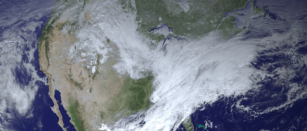
Photo from NASA
By Kerry McClay, WWA SnowSchool Director (November 6, 2024)
It’s the early snow season, and we here at Winter Wildlands Alliance and SnowSchool have been getting a lot of questions about what our predictions are for the winter’s snowfall. When you are a winter-focused organization it naturally means you have special insight into the happenings of one of the most powerful, yet elusive, forces of nature on the planet. But it also tends to mean that, at least in the eyes of the general public, you are partially responsible for winter weather. So whatever amount of snowfall Old Man Winter (or in this case La Niña) decides to bring forth this season, we at WWA are simultaneously preparing to raise our frost-covered mittens in wintry triumph and/or apologize in slush-induced shame.
With the current NOAA chatter leaning toward the emergence of a “weak La Niña” pattern, it might seem like science is suggesting we should mostly plan on the latter scenario. But sit tight Snow White! More than one interpretation is possible…
What is a “weak La Niña” winter?
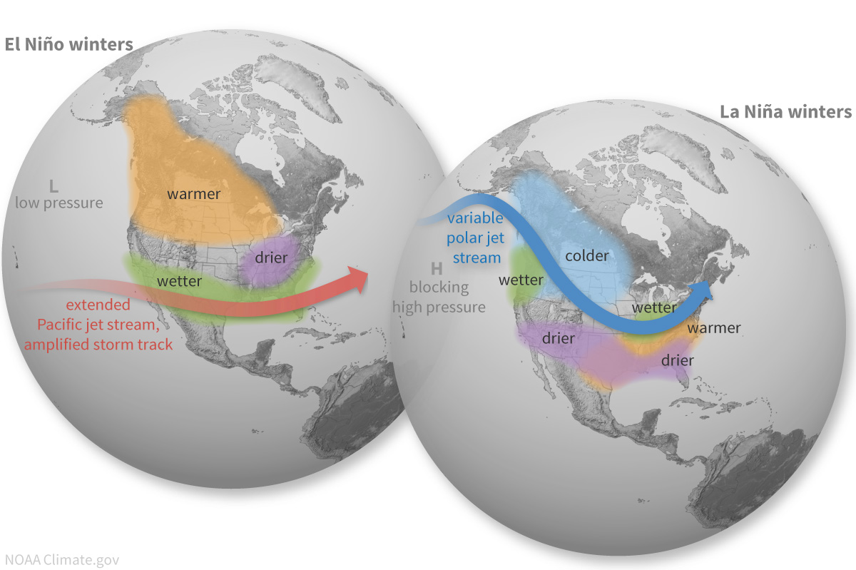
First off, in quick review, La Niña describes the global weather pattern that follows when ocean temps in the equatorial Pacific are cooler than average. This is the opposite of El Niño, which happens when ocean temps are warmer than average. During a typical La Niña winter in North America, the polar jet stream blasts across the northern United States bringing cold air and precipitation, while the southern United States is drier and warmer than average.
While last winter in North America saw an El Niño pattern, the previous three were La Niña events (read more about the rare Triple Dip La Niña here).
A “weak La Niña” occurs when Pacific ocean temps are only mildly cooler than normal, between -0.9° and -0.5°, compared to strong La Niña events (-1.5°C). These events typically form later in the fall and may fade by the end of winter, unlike stronger La Niña patterns, which can last well into the calendar year. For this season, the forecasted mild La Niña might signal a wetter winter in northern regions and a drier, warmer season in the southern U.S.
A big positive of this forecast for a mild La Niña is that our friends in the Great Lakes region can look forward to the end of their drought! But the glass-is-half-empty snow prediction would suggest a dry and warm winter in the southern United States and a slightly wetter than average winter up north. Ho-hum.
Snow Predictions from SnowSchool’s Favorite Snow Scientists:
Here at WWA we keep tabs on our favorite snow scientists—the experts who’ve helped us create hands-on snow science learning experiences for over 500,000 SnowSchool kids, especially when they make us smile with predictions about an impending big snow year! Here is what they are predicting for this season:
- Ron Abramovich, retired head of the Idaho NRCS Snow Survey program, sees this year’s predictions in a multi-year context. “Strong or weak La Niña, it doesn’t really matter for years following a strong El Niño like last year. Years that follow seem to have a lot of energy to release,” says Abramovich.
- Hans-Peter Marshall of NASA SnowEx program and the BSU CryoGARS group agrees, saying, “I’m going with Ron Abramovich… it might be most similar to 2017—hoping for a big year!”
“Nothing can be guaranteed,” Abramovich elaborated, “but with wild weather around us, there is no reason not to expect the extreme and wild weather to continue. We are not living in the calm and quiet doldrum years like the early 2000s. Pete Parsons from Oregon Department of Forestry takes an analytical approach, looking at past years with similar Pacific Ocean and atmospheric conditions. His analog years are 1967, 1993, and 2017—all of which brought near-normal to above-average snow years in central Idaho, with 2017 being a huge winter with 45 Atmospheric Rivers hitting the West coast.”
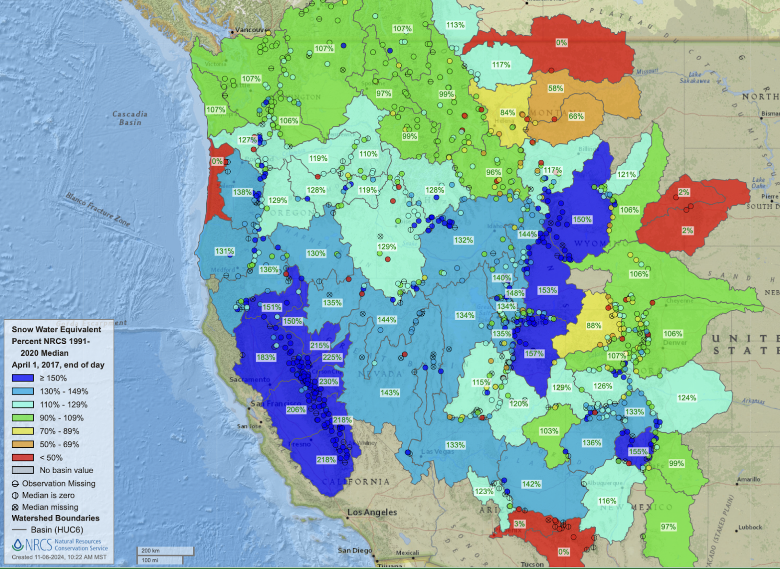
A fun experiment is to grab those years that match current conditions and plug them into the NRCS Interactive SNOTEL Map. For example, 2017 was relatively slow to start but really started to snowball mid winter. By April 1st you can see on the NRCS SNOTEL map (above) that almost every river basin across the western US was at or above the median historical snowpack level. April 1 is the date snow hydrologists have historically used to measure a season’s cumulative snowpack. And above average snowpack levels in many western watersheds were also observed for April 1st in 1993 and 1967. So bring on the snow!
It’s important to clarify that not all snow researchers in all locations are anticipating an enormous snow year.
- Longtime SnowSchool collaborator Meghan Collins of the NASA-funded Mountain Rain or Snow citizen science project was inclined to stick with the NOAA forecast for modestly above average precipitation in the northern regions. “NOAA is my go-to” Collin said, “Their seasonal forecasts share the probability of snowfalls above or below average over the next several months, but the technology isn’t advanced enough to predict just how much we’ll receive. We’ll just have to wait for the near-term forecasts each week!”
- And in California’s Sierra Nevada, our friend Ned Bair, climate scientist with Leidos and UC Santa Barbara snow researcher, would rather wait until April for this game. That not being an option, he responded: “For the Sierra, I think drier than normal but that’s just based on having one huge (2023) and one normal (2024) year in a row. Zero scientific evidence.”
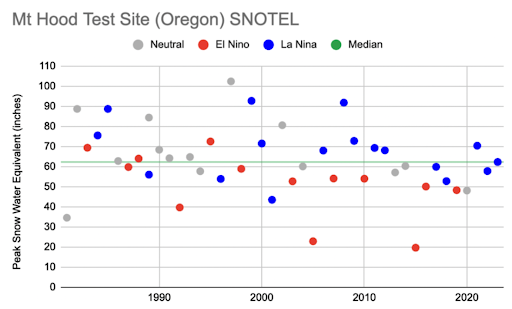
- David Foster-Hill of Community Snow Observations (a citizen science project focused on backcountry snowpack depth) weighed in with a prediction for his home range in Central Oregon. After running an analysis of his local Mt Hood SNOTEL station data (left) comparing El Niño to La Niña winters, he pointed out that most La Niña years are above the median snowpack. “Sure there is plenty of variability… but on average La Niñas are good to us…. Do I feel good about the ski season? I have already waxed my skis, if that is any indicator.”
In summary, it is still early to tell just how snowy this winter will be, but the signs are leaning toward at least a slightly above-average season in some areas. Whether you’re feeling “snow-ptimistic” or cautious, get ready to embrace whatever Old Man Winter brings our way!
What are your predictions for this season? Let us know, and let’s hope for deep snow!


